Huntsville extends greenway network with two major expansions
Published on February 12, 2026
Huntsville is taking the next step in expanding its greenway network with two significant projects funded through partnership agreements with the Alabama Department of Transportation (ALDOT).
These include:
- A 2.4-mile multiuse path along Bailey Cove and Four Mile Post roads in south Huntsville
- Phase II of the Miller Branch Greenway, a 1.6-mile segment in west Huntsville
Both projects will utilize Transportation Alternatives Program (TAP) funds, a federal program administered by ALDOT that supports pedestrian and bicycle infrastructure.
“Huntsville’s greenway network is something we have intentionally championed and advanced over the past 20 years,” said Mayor Tommy Battle. “These trails are more than recreational amenities – they are transportation corridors and connect neighborhoods to schools, jobs, shopping and parks. More importantly, they give our residents and visitors safe, multimodal options for how they move throughout our city.”
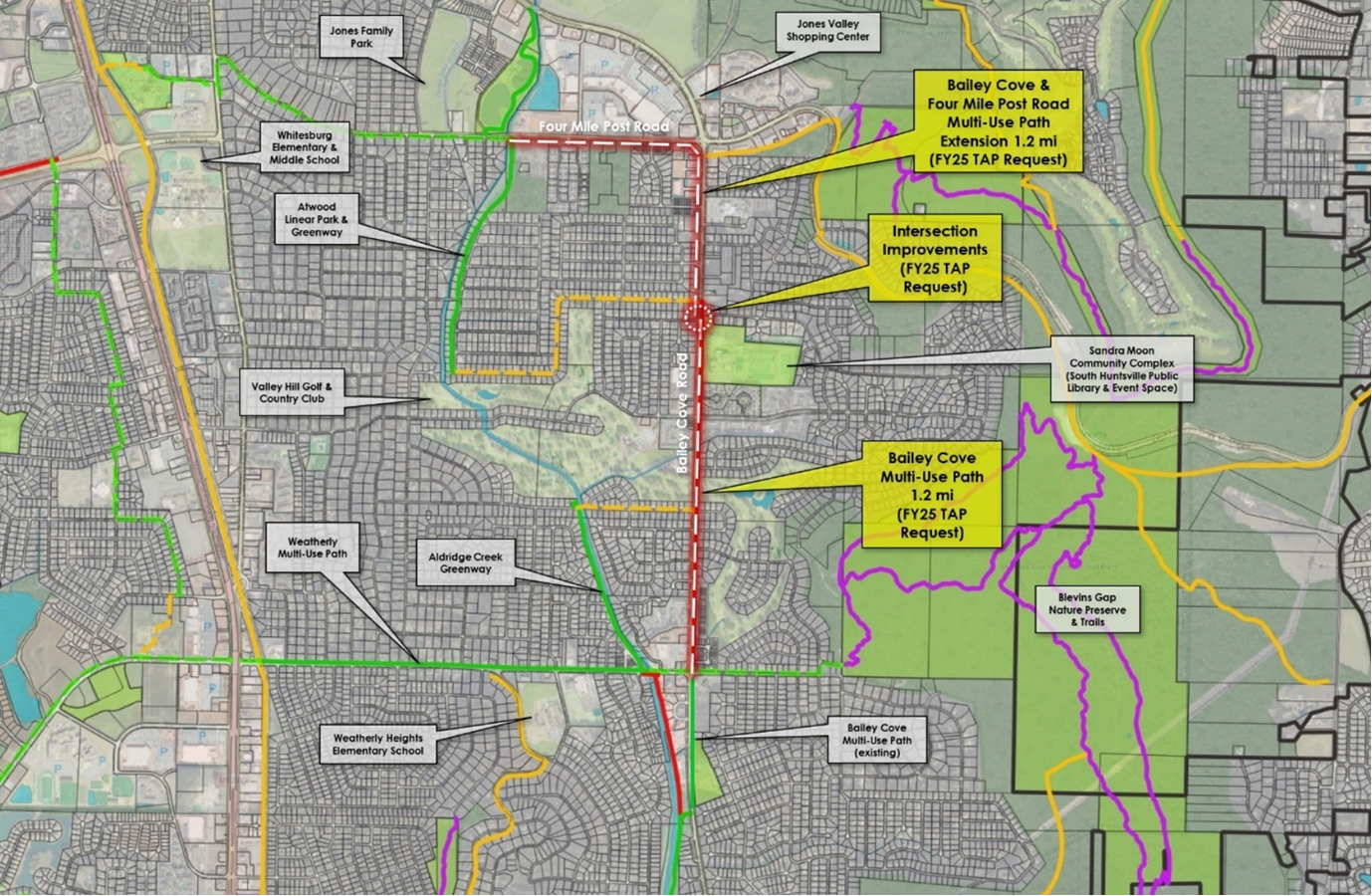
Bailey Cove Multi-Use Path
The Bailey Cove project will create a continuous 12-foot-wide, ADA-compliant multiuse path between Weatherly Road and Four Mile Post Road in south Huntsville. The route will connect neighborhoods, schools, shopping areas and the Sandra Moon Community Complex, and will ultimately tie into the Aldridge Creek Greenway.
In addition to the new path, the project includes safety improvements at the Bailey Cove Road and Blevins Gap Road intersection. Upgrades will feature improved crosswalks, accessible pedestrian signals, traffic-calming measures and intersection adjustments designed to make the area safer for walkers, cyclists and drivers. The new multiuse path will provide residents, and students and seniors, with a safe, protected alternative to driving short trips.
The total estimated project cost is approximately $1.8 million. TAP funding will contribute roughly $800,000 to the project.
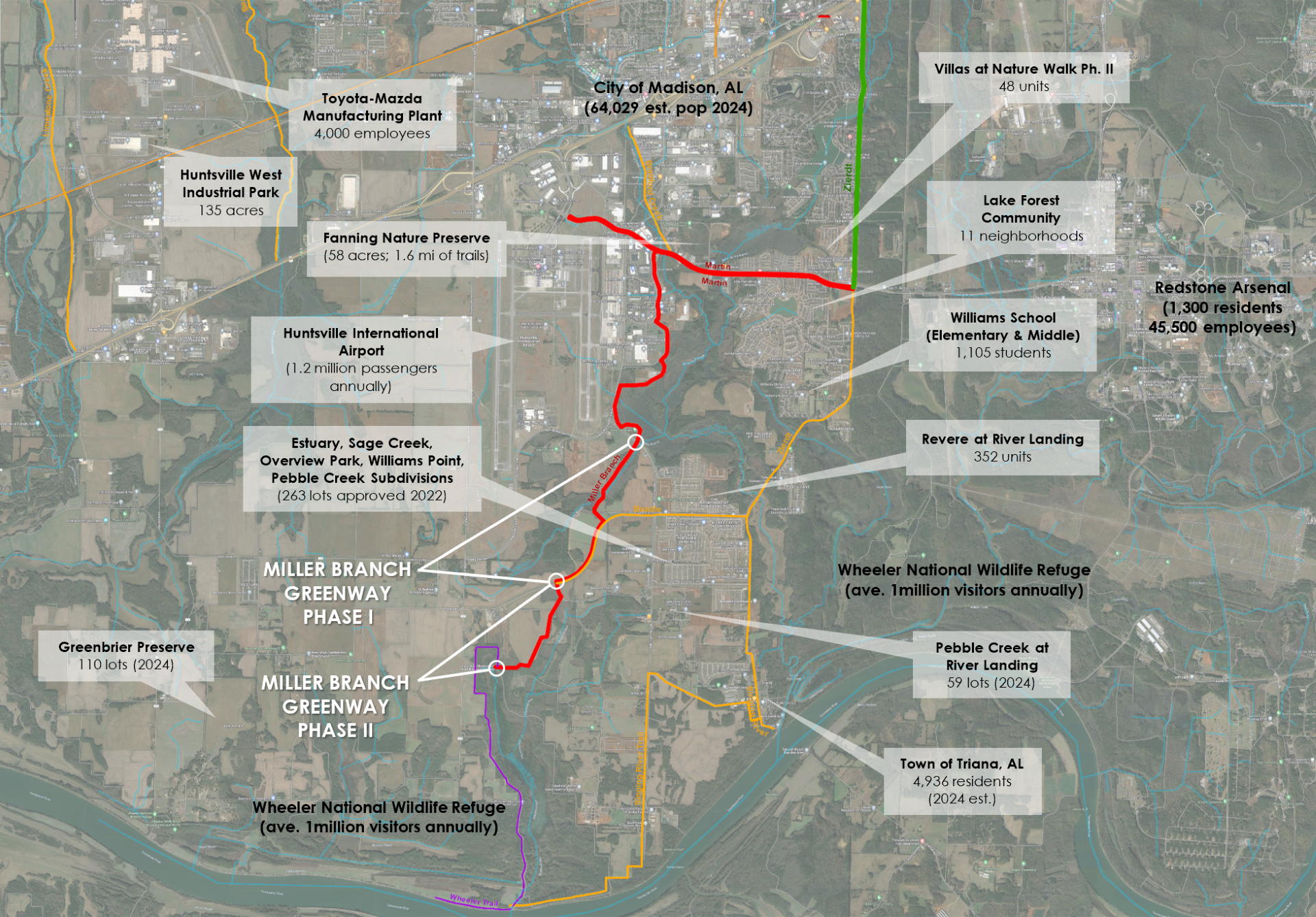
Miller Branch Greenway Phase II
The 1.6-mile Miller Branch Greenway Phase II will extend the existing trail in west Huntsville from Swancott Road south toward Wheeler National Wildlife Refuge. The 12-foot-wide asphalt path will run along Miller Branch Creek and remain entirely on City property.
This segment is part of a larger multi-phase effort to connect Dallas Fanning Nature Preserve near Martin Road to the Zierdt and Beadle greenways, the Singing River Trail in Triana, and ultimately, existing trails within Wheeler Wildlife Refuge.
When complete, the west Huntsville greenway network will offer nearly 30 miles of interconnected trails, providing recreational access, environmental connectivity and safe commuting options in one of the area’s fastest-growing corridors.
The total estimated cost for Phase II is about $1 million. TAP funding will provide approximately $797,464 with the City contributing a $199,366 local match.
Investing in connectivity
Both projects reflect the priorities identified in Huntsville’s BIG Picture/Greenway Master Plan and through public input sessions, where residents consistently emphasized the need for better connectivity across the city.
Through its partnership with the Land Trust of North Alabama and ALDOT, the City continues to expand its network of pedestrian and bicycle infrastructure. Huntsville currently has approximately 130 miles of greenways, bikeways and trails, with additional miles planned each year.
Construction timelines will be announced once final engineering and coordination with ALDOT are complete.