Revised Greenway Plan Expands Network and Partnerships
Published on
After months of public input and planning, the City of Huntsville has updated its Greenway Plan to reflect the community’s vision for an expanded system of connected trails and greenways to serve as recreation and transportation corridors.
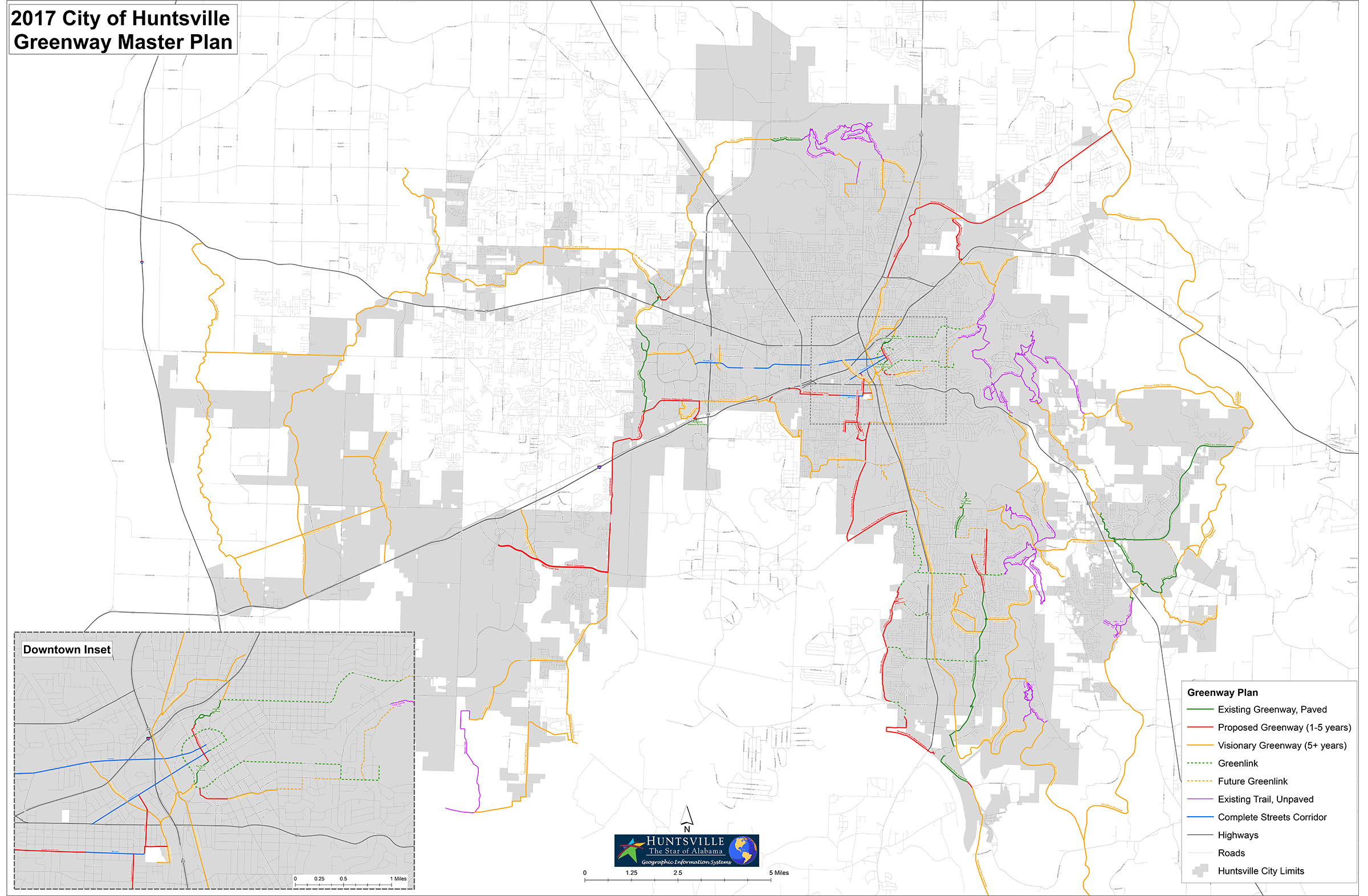
The revised plan calls for more than 312 miles of greenways within a network that involves multiple projects in different parts of city. About 73 miles have already been built and 44 miles are targeted for construction in the next one to five years.
“The genesis of this update is the significant amount of public interest we’ve seen throughout our BIG Picture planning process,” said Mayor Tommy Battle. “We heard our residents loud and clear. They love our greenways and they want us to build more. We revised our plan and our process to help us deliver on this vision.”
We heard our residents loud and clear. They love our greenways and they want us to build more. We revised our plan and our process to help us deliver on this vision.”
Battle called on Long-Range City Planner Dennis Madsen to expand the greenway plan and to look for new opportunities for funding and engagement.
Madsen began by looking at the principles in the 2008 Greenway Plan with an eye on some new goals:
- Create better access to the greenways
- Design greenways to connect to places people need to go (shopping/work/recreation)
- Clarify types of greenways for the plan (trails, trail links, complete streets)
- Develop public-private partnerships to expedite implementation
- Target opportunities for construction (combine with road projects)
- Identify funding sources
“We’ve updated the plan and we’re implementing the plan,” said Madsen. “It is visionary, but it is real. While we won’t build it all at once, we are committed to the vision and making it happen.”
What’s new in the Greenway Plan
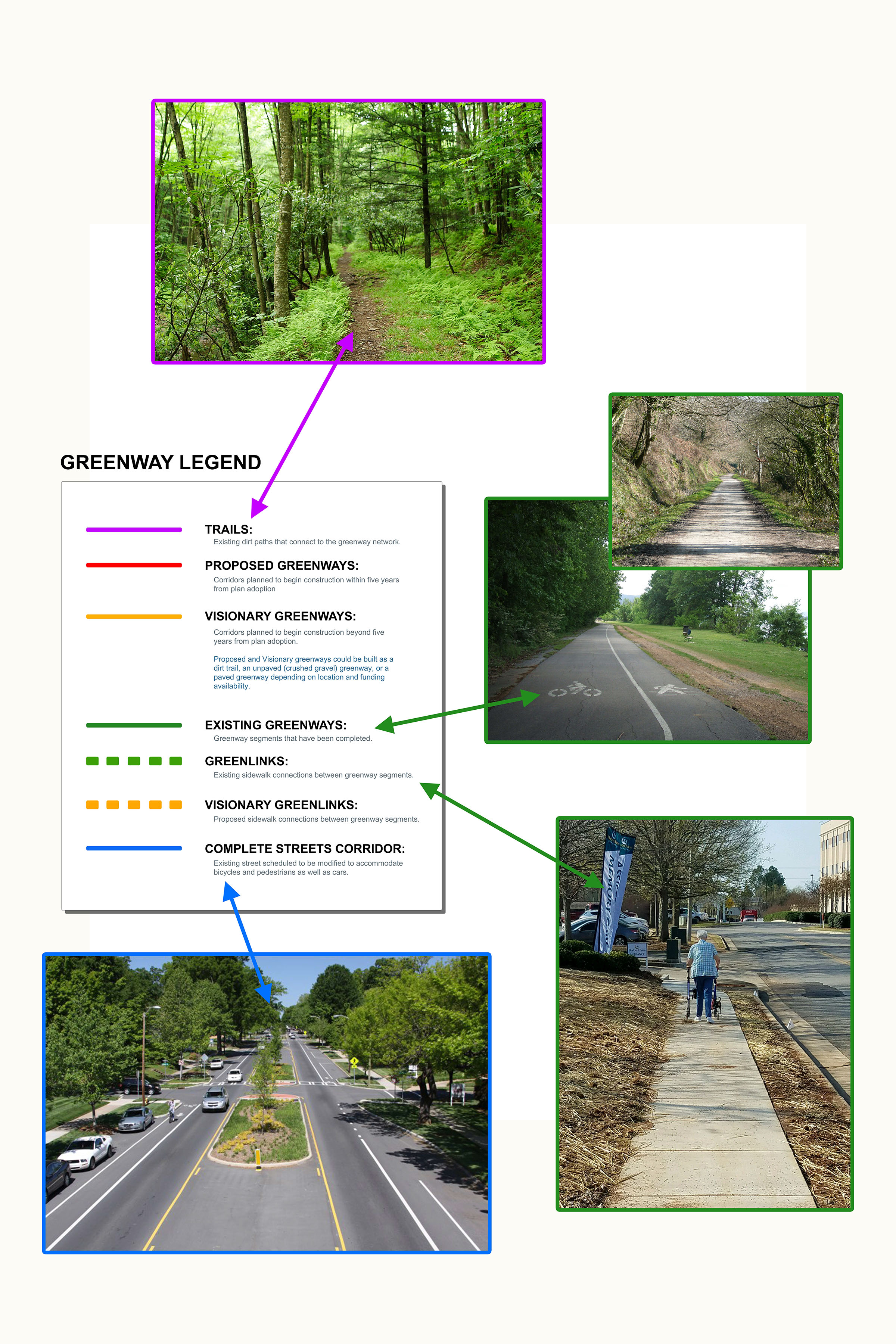
Planners expanded their thinking in the updated plan to include short- and long-term projects and different types of greenways and connectors, everything from dirt paths and crushed gravel trails to urban cycle tracks, paved greenways, and greenlinks – existing sidewalk connections between greenways.
They further believe greenways offer opportunities to engage the commercial sector. Greenways attract people and businesses get excited to be where people congregate. Housing comes next, so the network becomes an as much as an economic generator as a community amenity.
A plan of this magnitude requires funding and partners. The cost of a greenway can vary from tens of thousands of dollars to millions, depending upon land acquisition, design, and materials used for construction. The City is taking a multi-faceted approach in funding, starting with $8 million in its 10-year capital budget. The next key piece is public-private partnerships.
“We’re hoping our public investment will spur more private support and involvement,” said Madsen. “We’ll be exploring more grant opportunities, private donations and foundations, and we’ll identify funded roadway projects where greenways will be a good fit.”
A catalyst in this process has been the City’s partnership with the Land Trust of North Alabama. They’ve brought their expertise to the updated plan and allowed the City to think in broader terms of a regional network, helping to jump municipal boundaries to ensure trails link to a wider regional greenway network, connecting Huntsville to Athens, Madison, Decatur and a multitude of North Alabama communities.
“We love collaborating on projects that enhance quality of life in our community and provide opportunities for everyone to access and enjoy the outdoors,” said Marie Bostick, Executive Director, Land Trust of North Alabama. “The Big Picture Greenway Plan will do just that, and based on the involvement and enthusiasm we received throughout the process, this is obviously something Huntsville wants and needs.”
Mayor Battle has long maintained that all major civic projects worth doing are public-private partnerships. “It’s a big part of this process,” said Battle. “When you bring the resources of the City and our non-profit partners and combine that with the resources of business and civic patrons, there’s no limit to what we can accomplish. What we all bring to the table is key.”
Informed by The BIG Picture comprehensive planning process, the Greenway Plan is designed to foster and promote tourism, economic development, health, recreation, diverse and safe transportation options, and to connect the community’s cultural heritage and natural beauty.
Like the BIG Picture master plan, the updated greenway plan is a “livable” guide with the flexibility to adapt and grow as the City evolves. View the plan HERE.
Greenway Glossary
Trails: Existing dirt paths that connect to the greenway network.
Greenlinks: Existing sidewalk connections between greenway segments.
Visionary Greenlinks: Proposed sidewalk connections between greenway segments.
Complete Streets Corridor: Existing streets scheduled to be modified to accommodate bicycles and pedestrians as well as cars.
Proposed Greenways: Corridors planned to begin construction within five years from plan adoption.
Visionary Greenways: Corridors planned to begin construction beyond five years from plan adoption. Proposed and Visionary greenways could be built as a dirt trail, an unpaved (crushed gravel) greenway, or a paved greenway depending on location and funding availability.
Existing Greenways: Greenway segments that have been completed.